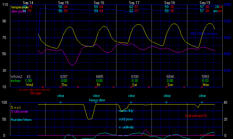
Today
|
Mostly cloudy to cloudy in the morning, becoming dense overcast in the afternoon. Patchy light fog. A chance of rain in the morning, then rain likely in the afternoon. Scattered thunderstorms likely. High 74°, but temperatures falling in the afternoon. Wind south around 4 mph in the morning, becoming east-southeast in the afternoon. Chance of precipitation 80 percent. Precipitation mostly between half an inch and one inch. |
Tonight
|
Cloudy in the evening, becoming partly to mostly cloudy after midnight. Patchy light fog. A chance of rain in the evening, then a slight chance of rain after midnight. Precipitation showery or intermittent. Low 65°. Wind south-southeast around 3 mph. Chance of precipitation 40 percent. Precipitation mostly around a tenth of an inch. |
Wednesday
|
Mostly cloudy in the morning, becoming partly cloudy in the afternoon. Light to moderate fog in the morning. A chance of rain in the morning, then a slight chance of rain in the afternoon. Precipitation showery or intermittent. High 84°. UV index up to 9. Wind south-southwest around 3 mph in the morning, becoming 6 mph in the afternoon. Chance of precipitation 40 percent. Precipitation mostly less than a tenth of an inch. |
Wednesday night
|
Partly cloudy in the evening, becoming partly to mostly cloudy after midnight. Moderate fog after midnight. A slight chance of rain in the evening, then a chance of rain after midnight. Scattered thundershowers possible. Low 68°. Wind southwest around 5 mph in the evening, becoming west after midnight. Chance of precipitation 40 percent. Precipitation mostly less than a tenth of an inch. |
Thursday
|
Cloudy in the morning, becoming partly to mostly sunny in the afternoon. Light to moderate fog in the morning, then patchy light fog in the afternoon. A chance of rain in the morning, then a slight chance of rain in the afternoon. Scattered thundershowers possible. High 81°. UV index up to 9. Wind west around 6 mph, gusting to 17 mph. Chance of precipitation 40 percent. Precipitation mostly less than a tenth of an inch. |
Thursday night
|
Clear in the evening, becoming mostly clear after midnight. Moderate fog after midnight. Low 67°. Wind west around 5 mph. |
Friday
|
Sunny. Moderate fog in the morning. High 83°. UV index up to 11. Wind west-northwest around 9 mph, gusting to 19 mph. |
Friday night
|
Clear in the evening, becoming mostly clear after midnight. Patchy light fog after midnight. Low 61°. Wind west-northwest around 6 mph, gusting to 17 mph. |
Saturday
|
Sunny in the morning, becoming partly to mostly sunny in the afternoon. Patchy light fog in the morning. High 83°. UV index up to 11. Wind west-northwest around 8 mph, gusting to 17 mph. |
Saturday night
|
Mostly cloudy in the evening, becoming cloudy after midnight. A slight chance of rain after midnight. Precipitation showery or intermittent. Low 64°. Wind west-northwest around 4 mph. Chance of precipitation less than 20 percent. Precipitation mostly less than a tenth of an inch. |


